South ShoreWelcome to Yellville, Arkansas
Take a Virtual Tour of YellvilleWelcome to Yellville

Founded in 1835 and later named for Arkansas Governor Archibald Yell, Yellville is a town of tradition as well as tourism.

A prominent military and governmental leader of the early 1800s, Governor Yell had been in the War of 1812 and was a Federal judge, a Congressman and Governor. Incorporated in 1855, Yellville was first known as Shawnee Town before it took the name of Yellville. The town is now known far and wide for its annual Turkey Trot Festival held the second weekend in October, an event that includes the National Wild Turkey Calling Contest.

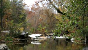
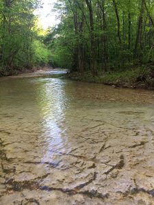
Crooked Creek, a famed smallmouth bass stream and spring float stream, runs right through town. Yellville's City Park affords access to Crooked Creek with a canoe landing, lighted walking trail, ball diamonds and sports court.

Marion County Courthouse
The Historic Marion County Courthouse
in the center of the Yellville square.

This genuine Ozark Mountain village shares its pastoral scenery with those who visit to fish and float the Buffalo National River and other nearby streams. 

Yellville residents work in small industries, in lumber, agricultural and tourist trades. They provide public services as they teach the 1100 students in the Yellville-Summit schools. After graduation, students may pursue higher education nearby at Arkansas State University Mountain Home located 25 miles to the east, and North Arkansas College at Harrison, 25 miles to the west. 

The climate is mild with average winter temperatures of a moderate 35-40 degrees. Average annual rainfall is 40-45 inches.

Divider

Click Here for City Map

Arkansas Map Arkansas Map South ShoreArkansas MapYellville is a town of approximately 2,000 population located in north central Arkansas, about 30 miles south of the Arkansas-Missouri state line. It is accessed by a major non-Interstate east-west route, U.S. Highway 412/62, and is on north-south Arkansas Highway 14, a popular scenic highway. Less-traveled state highways 235 and 202 also lead into Yellville. The town is situated on Crooked Creek, a popular fishing stream during wet weather, and is a northern gateway to Buffalo National River.

Nearest Interstate highways are Interstate 44 (100 miles north) and Interstate 40 (100 miles south).

Driving Distances from
Yellville, Arkansas

City Distance
Atlanta, Georgia 673 miles SE
Chicago, Illinois 612 miles NE
Dallas, Texas 447 miles SW
Kansas City, Missouri 278  miles NW
Little Rock, Arkansas 142 miles S
Memphis, Tennessee 221 miles SE
New Orleans, Louisiana 609 miles SE
New York, New York 1,292 miles NE
St. Louis, Missouri 313 miles NE
Tulsa, Oklahoma 210 miles W
Wichita, Kansas 388 miles W

Divider

Other Favorite Links:


Natco's Online Yellow Pages

Add or Change Your Business Listing


Details About the Program and Price List


Web Site Comments
 

Visit Arkansas!

Logo of the Development Industrial Network of Arkansas

Natco Technologies - Internet Service ProviderNorthern Arkansas Telephone Company - Natco

URL: www.yellvilleweb.com
©2007. All rights reserved.
Copyrights, Credits & Privacy
Information for this site has been gathered from several sources. This site is updated frequently; however, please contact the Chamber of Commerce  or City Hall to obtain the most current information.Bobby Approved (v 3.2)


Divider
NATCO building in Flippin, Arkansas. South Shore, Bull Shoals Lake, Arkansas

South Shore was founded and is fully supported by NATCO, 
Northern Arkansas Telephone Company.

02.21.2007 bjm332gf0